
Google Earth: Where Oceanic Flight 815 was LOST
After recording my latest podcast episode on Wednesday night (editing in progress—check back here soon), I decided to download Google Earth and map out the locations we discussed. Here's a preview for what I came up with (click to enlarge):
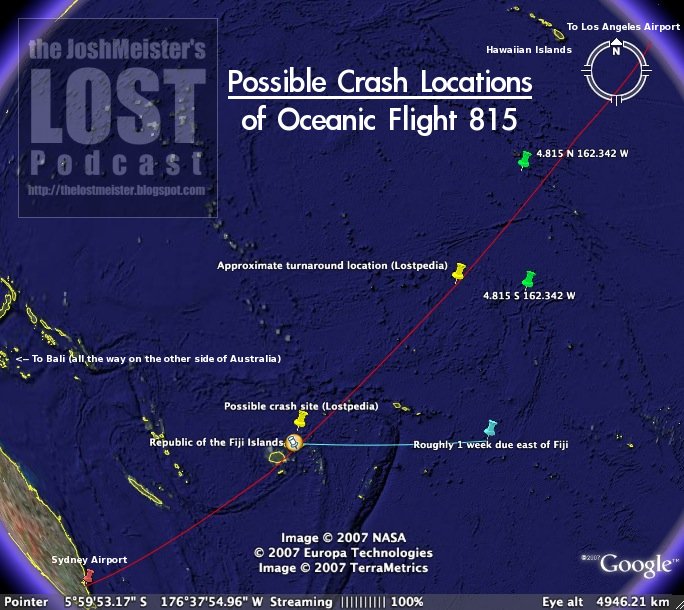
I made a Google Earth (.kmz) file containing pushpins for:
- 4.815 N 162.342 W
- Longitude and latitude coordinates based on "the numbers," near Oceanic Flight 815's flight path
- 4.815 S 162.342 W
- A similar location, also near the flight path but south of the equator
- A location that's roughly 1 week due east of Fiji traveling at a consistent rate of 9 knots
- Desmond said in "Live Together, Die Alone" that "bearing due west and making 9 knots [he] should have been in Fiji in less than a week." If Desmond is correct, then the island is roughly 1,700 miles or 2,700 km due east of Fiji, if not closer. This site is roughly one week due east of Fiji at a consistent speed of 9 knots (about 10 miles per hour or 17 km per hour).
- Also mapped is a line connecting that point to Fiji, indicating other possible crash sites that would be less than a week away
- Republic of the Fiji Islands
- Sydney Airport (aka SYD or Kingsford Smith International Airport)
- Los Angeles International Airport (aka LAX)
- The flight path for SYD to LAX (based on this information)
- The approximate location where the plane turned around to head back toward Fiji, according to the pilot in the "Pilot" episode
- 4.403 S 168.119 W, based on this analysis at Lostpedia
- In the "Pilot" episode, the pilot said, "6 hours in. Our radio went out, no one could see us. We turned back to land in Fiji, by the time we hit turbulence we were 1,000 miles off course. They're looking for us in the wrong place."
- Based on Lostpedia's estimated turnaround location, it's somewhat surprising to me that the pilot chose to turn back, because he could have just as easily continued in roughly the right direction and veered off to land in Hawaii if radio contact could not be reestablished. The Hawaiian islands (including Oahu, where LOST is filmed) can be seen near the upper-right corner of the image above
- An approximate location where the plane might have crashed, based on the turnaround point and a comment from flight attendant Cindy
- In "The Other 48 Days," Cindy said, "Before the crash, the pilot said we'd lost communication; we were turning back. We were flying for two hours in the wrong direction. They don't know where to look."
- Bali, Indonesia
- In "The Brig," Naomi said, "They found the entire plane off the coast of Bali. In an ocean trench four miles deep. They sent down cameras in these little robots to survey the wreck. The bodies were all there."
- It would be very, very strange for Oceanic Flight 815 to have crashed near Bali because it's ridiculously far away from the flight path from Sydney to Los Angeles; what could possibly explain the flight crashing there, and how did anyone find it there?
- It should be noted that Naomi did NOT say that the island was 80 nautical miles east of Bali. She said that the freighter from which her helicopter lifted off was 80 nautical miles west of the island, which is very far away from Bali, and thus this information is not terribly helpful in determining where the island is located
Don't have Google Earth?
- You can download Google Earth here, or...
- You can view most of the locations in this screenshot
Labels: episode commentary, theories
posted by Josh Long at 10:05 AM
![]()
![]()


1 Comments:
I mapped the location of the island a long time ago based on the 1000 miles the pilot said they were off course and Desmond's attempt to get back to Fiji but I only posted it at the 'Lage. Here's what I came up with: My Lost Map
Post a Comment
<< Home